Storm Chase Log 31 May 2013
Chaser: Dorian J. Burnette
Preliminary Destination: El Reno, OK
Note: Images have been decreased in size. Click on an image to view a larger version.
This was Day 2 of a two-day storm chase in OK (click here for the Day 1 log). The year 2013 was my 17th year storm chasing, and the total amount of damage to my car has been minimal all these years (hail damage only once), since I am not interested in being super-aggressive. In fact, I generally consider myself a wuss when it comes to getting close to tornadoes. I do have an increased tendency to get a bit more aggressive when I am by myself though like I was on this storm chase. Of course, even despite best efforts, the occasional close call will occur. I have had a few of those, and I don't like them. However, this day takes the cake--I was way too close to the El Reno tornado, and I am chagrined about that.
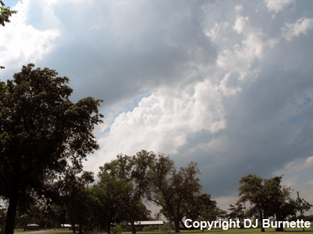
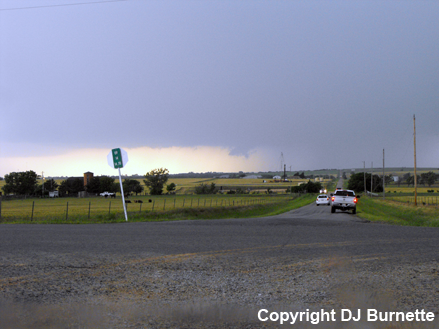
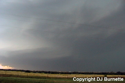
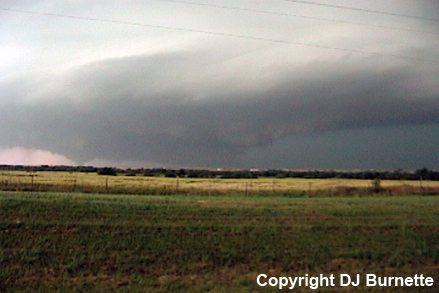
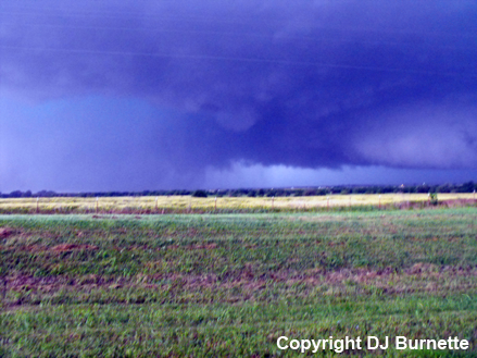
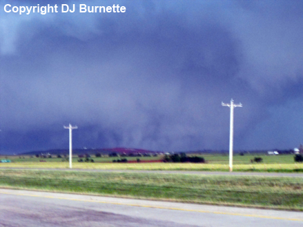
I arrived in El Reno in the early afternoon, had lunch, and then located a city park, where I could continue to keep a close eye on conditions under the comfortable shade of a tree. At 3:30 p.m. CDT, PDS tornado watch number 262 was issued for the area (PDS=Particularly Dangerous Situation). About 30 minutes later, towering cumulus clouds were observed near my location (images below; view is looking west from the westside of El Reno).
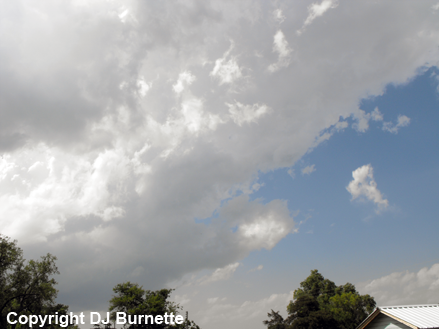
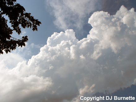
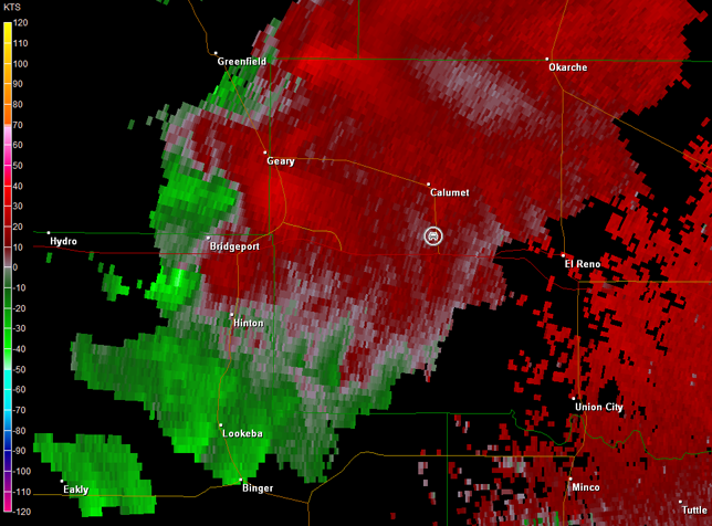
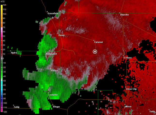
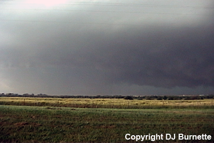
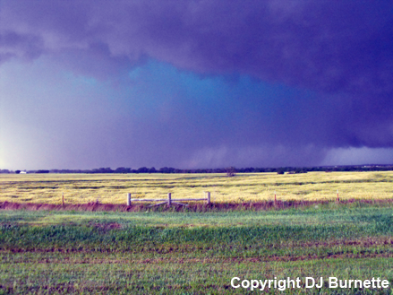
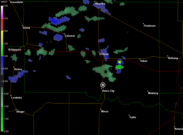
By 4:45 p.m. CDT, storms were exploding to the west of El Reno, and I moved west on I-40 to U.S. 270 and sat on U.S. 270 south of Calumet, OK to view the storms (images below; view is south of Calumet, looking west). Radar showed three individual storm cells with organization occurring on the backside of the main cell in vicinity of Bridgeport, OK (images below; car symbol denotes my location).
Norman, OK Storm Relative Velocity 2205Z
Norman, OK Base Reflectivity 2214Z
Norman, OK Storm Relative Velocity 2214Z
Norman, OK Base Reflectivity 2219Z
Norman, OK Storm Relative Velocity 2219Z
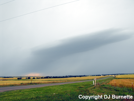
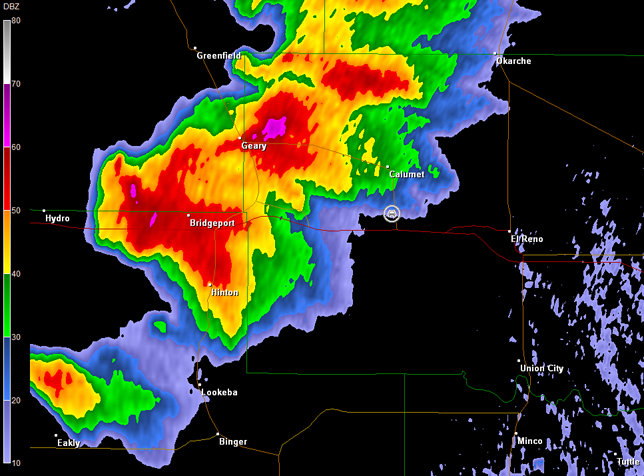
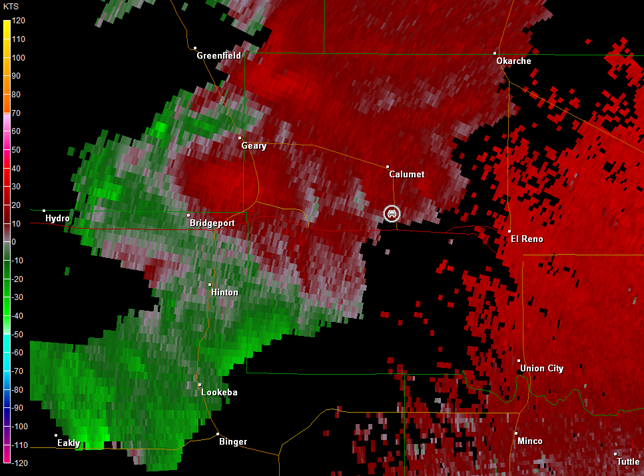
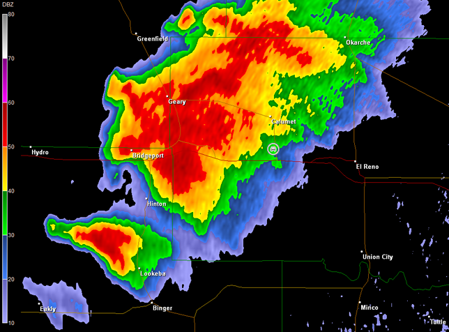
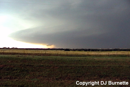
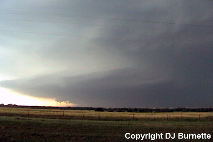
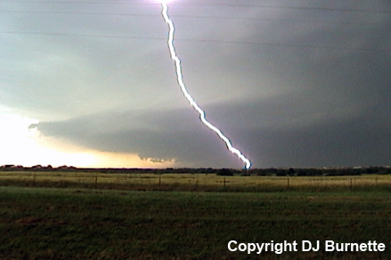
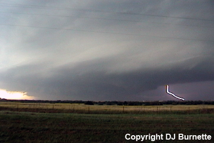
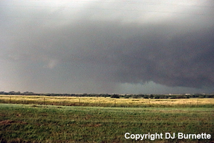
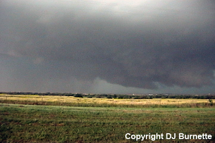
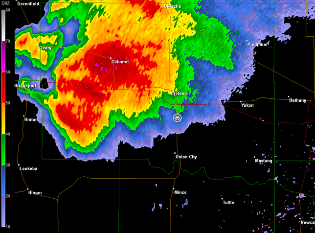
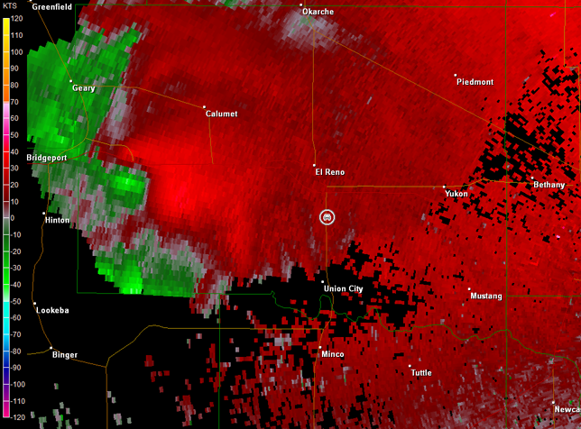
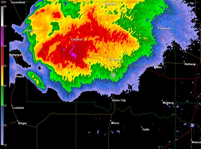
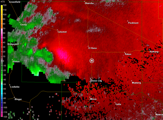
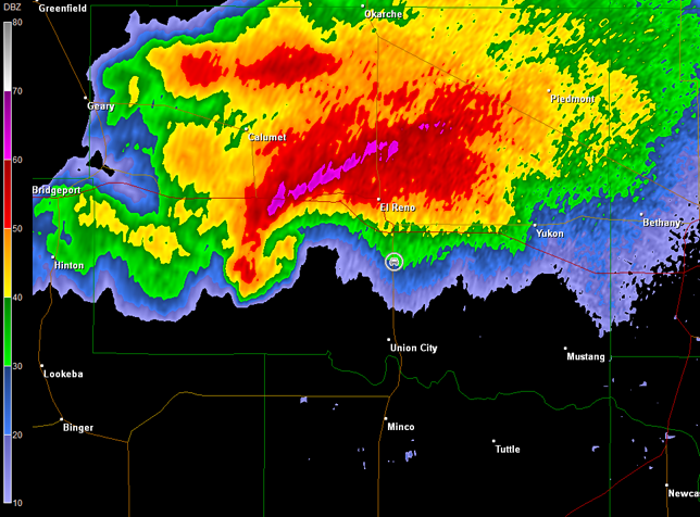
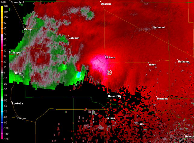
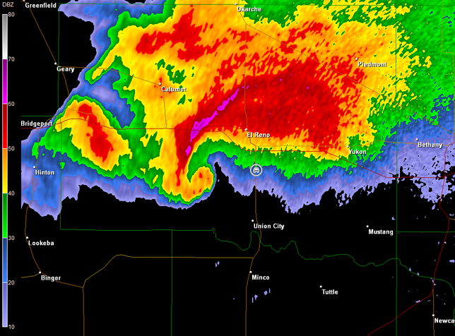
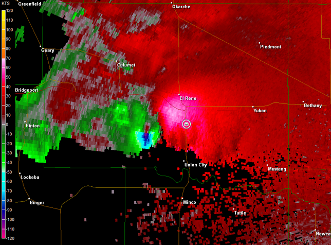
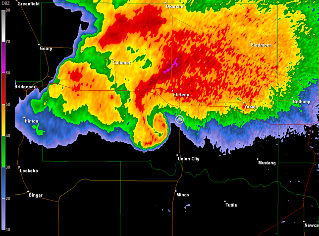
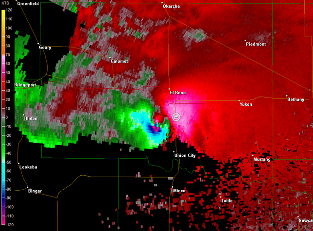
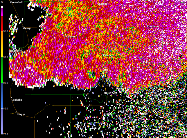
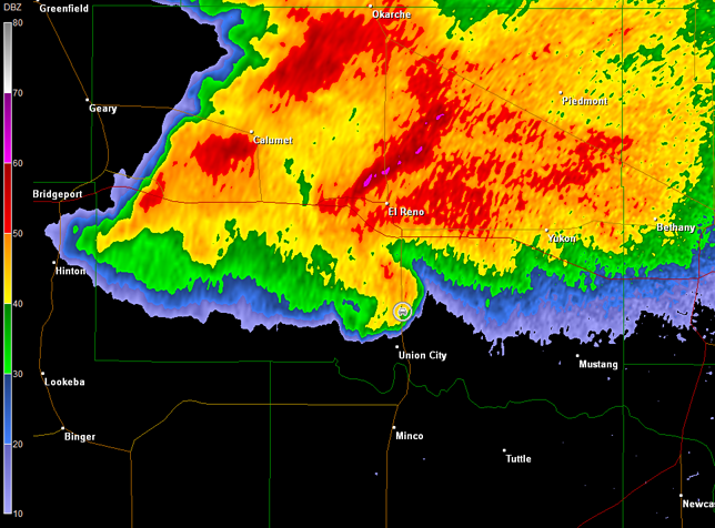
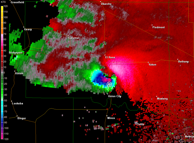
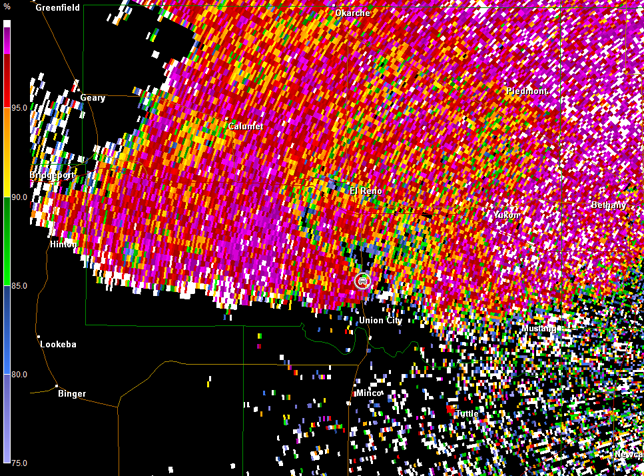
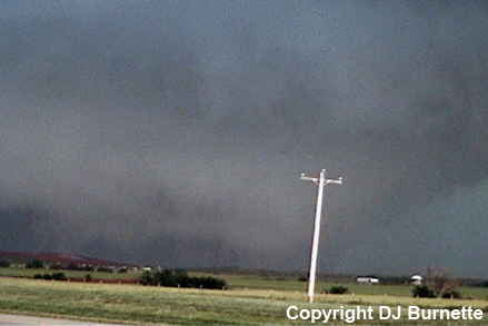
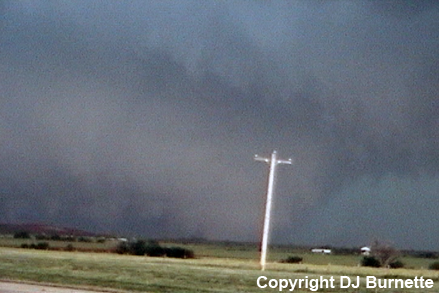
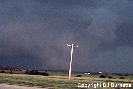
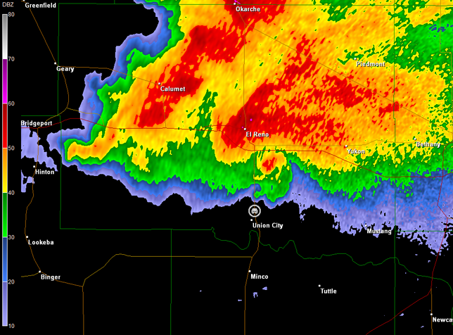
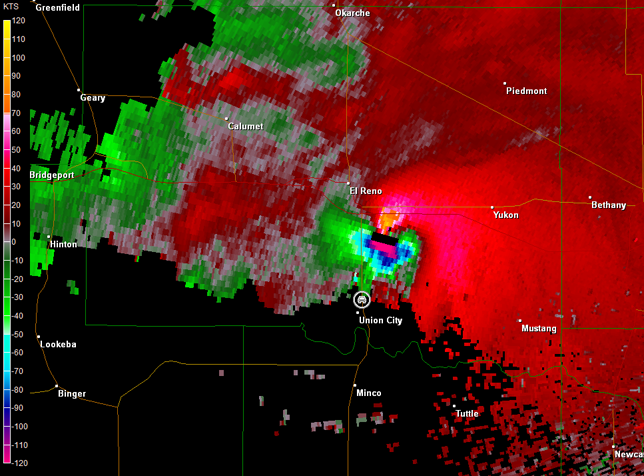
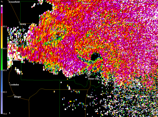
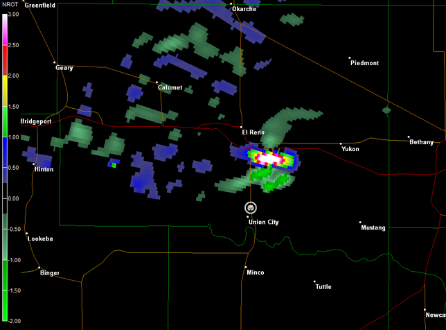
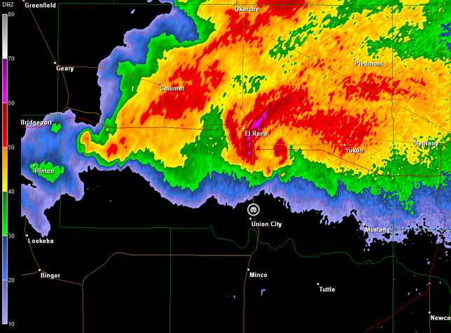
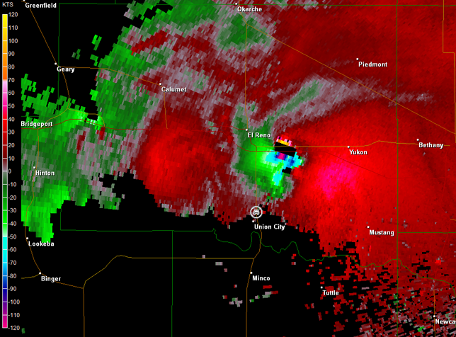
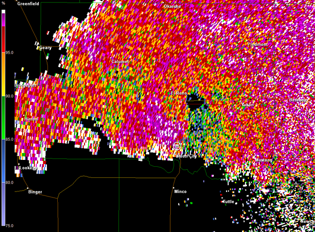
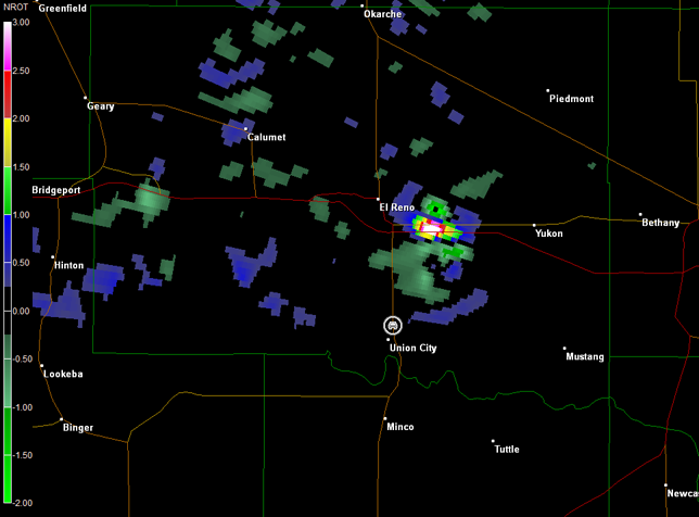
The dominant storm took a hard right turn east and was coming toward me. Therefore, I moved back south to I-40, then east on I-40 to El Reno, and finally south on U.S. 81. I pulled over at a good spot on U.S. 81 south of El Reno to allow the storm to come to me. I briefly observed a wall cloud while I was en route to this position on I-40. The storm closed in on my location over the next 35 minutes. The storm structure was impressive with plenty of cloud-to-ground lightning (images below; view is south of El Reno, looking west). Jeff House sent me a couple of text messages saying chasers had reported a tornado on the ground. I could not see it, but at times there were hints of a tornado well off in the distance. Upon reanalysis of the video, sheet lightning seems to have illuminated the tornado two times before rain wrapped around the circulation (sixth and seventh images below). The closer the storm got, the more I heard a whistling wind in the distance. Inflow winds dramatically increased at my location, and it was hard to stand up at times. I have felt those type of winds before--the storm was clearly creating its own environment. Radar imagery is included below, and the classic supercell look on the radar appeared (images below; car symbol denotes my location). The dual-polarization correlation coefficient product is included in the last series of radar images below. Note the low correlations juxtaposed well with the rotation indicated in the storm relative velocity data suggesting a tornado is on the ground and debris is being lofted (debris is of varying size, so correlation values decline).
Norman, OK Storm Relative Velocity 2237Z
Norman, OK Base Reflectivity 2246Z
Norman, OK Storm Relative Velocity 2246Z
Norman, OK Base Reflectivity 2256Z
Norman, OK Storm Relative Velocity 2256Z
Norman, OK Base Reflectivity 2305Z
Norman, OK Storm Relative Velocity 2305Z
Norman, OK Base Reflectivity 2309Z
Norman, OK Storm Relative Velocity 2309Z
Norman, OK Base Reflectivity 2314Z
Norman, OK Storm Relative Velocity 2314Z
Norman, OK Correlation Coefficient 2314Z
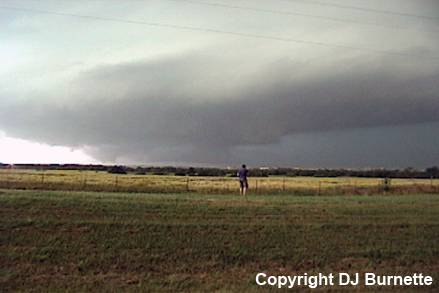
The storm had a consistent forward speed and direction up to now. Nevertheless, my instinct told me it was time to go south. I noticed a van to my south with a group of students still taking pictures, so I tried not to be a wuss and ignored the instinct. Let it be known that this was a big mistake! I should have left when my instinct told me to leave. I have to admit that I also found myself getting mesmerized by the storm. Regardless, it was clear that the bear's cage was coming right for me (bear's cage=curtain of rain wrapping around mesocyclone with the tornado inside; eastern edge of it is viewable in the bottom series of images above with a greenish glow to it in the two images on the bottom-right above). Waiting until the absolute last minute to move south put me in danger if the storm changed velocity. The large tornado doubled in both size and speed and turned left, as it approached and passed over U.S. 81. This rapid sequence of events caught many storm chasers off guard, including me. While such a sequence of events had never been observed before (per Tim Marshall and Greg Forbes at the 2014 American Meteorological Society Annual Meeting), rapid changes in a tornado's path are not uncommon. We need to be ready for those. My horrible experience follows reconstructed using a combination of memory, GPS coordinates, radar data, and the latest El Reno tornado track data available from the Norman National Weather Service Forecast Office (originally written in June 2013; updated February 2014).
I started south on U.S. 81 moving toward Union City, OK. The tornado accelerated and the amount of distance between me and the bear's cage was not enough. The rain curtain moved over my location. I have been in the bear's cage before, but not from the east side with a large tornado moving toward me. As I moved south, I looked at an ~45 degree angle and saw a tornadic circulation make contact with a structure and debris started flying. While this may have been the outer edge of the main tornado itself, it also may have been a suction vortex given the circulation of the main tornado was rapidly expanding to encompass much, if not all, of the bear's cage. Some pieces of debris were thrown in advance of the circulation across U.S. 81 and into my path. I was not able to tell exactly what these pieces were, but several pieces hit my car. One cracked the bottom-center of the windshield. Of course, I was focused solely on maintaining control of the car and moving south as fast as possible. The rain and debris made it hard to go more than 60 mph initially. As the tornado got even closer, I encountered an intense inflow jet into the tornado. I could not estimate the winds, but other chasers noted the winds were on the order of 80-100+ mph. I could feel the wind tugging on the car. My ears also popped from the pressure change taking place, so I knew the tornado was very close. The tornado crossed the road ~1.5 miles to my north. However, that is just the best estimated location of the center of the tornado. It was also growing to 2.6 miles wide at this time. Meanwhile, I encountered damaging winds associated with the rear-flank downdraft, as I continued farther south away from the tornado.
A Google Earth image is below denoting the El Reno tornado's track. These data were derived from the official National Weather Service damage survey and radar data from the University of Oklahoma RaXPol and the Norman, OK radar. Also included in this image is my track derived from the GPS. Radar data from the time when the tornado was crossing U.S. 81 are below the Google Earth map. My location is denoted with the car symbol. It is very likely that I encountered the outer circulation of this massive tornado per the Google Earth map and the radar data. This is a very bad location! I hope others can learn from this.
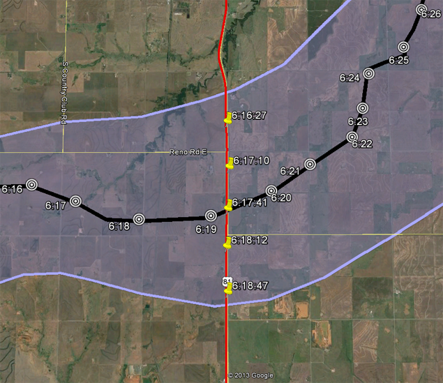
El Reno Tornado width (light purple shaded area), its center (black line), and the time the center was along the path (black and white targets; time in CDT). Also plotted are my GPS path (red) and the time I was along that path (yellow pushpins; time in CDT includes seconds). Note my GPS times relative to the tornado's times. Keep in mind the size of the tornado was growing from about 1 mile wide to 2.6 miles wide.
Norman, OK Storm Relative Velocity 2319Z
Norman, OK Correlation Coefficient 2319Z
Norman, OK Normalized Rotation 2319Z
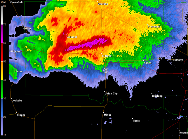
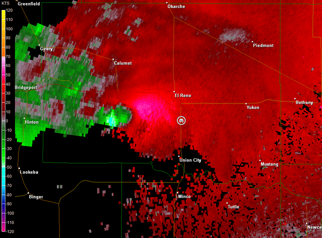
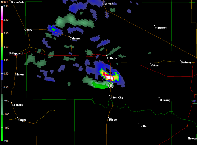
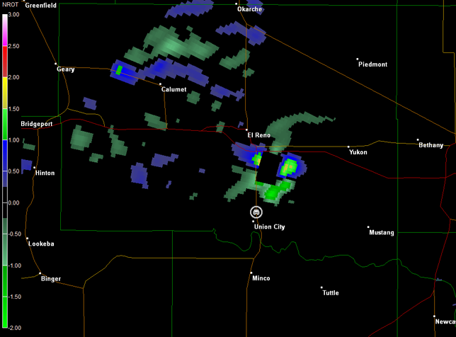
Somehow I was able to drive out of that with only a crack to my windshield. I stopped about one mile north of El Reno, looked over my left shoulder, and saw a violent, wedge tornado completely visible (images below; view is between El Reno and Union City, looking northeast from U.S. 81). This was when the tornado was at its maximum size and intensity. Radar data are also included below (car symbol denotes my location). Note also that because the storm relative velocity includes bad data in the lowest tilt, the normalized rotation product from GR2Analyst, used more and more on TV these days, is unable to deduce the tornado and goes to zero. The normalized rotation product from the next tilt up, also included below, did not have this problem. This is why the normalized rotation product should not be used by itself. Meteorologists will want to keep this issue in mind for future events.
Norman, OK Storm Relative Velocity 2323Z
Norman, OK Correlation Coefficient 2323Z
Norman, OK Normalized Rotation 2323Z
Norman, OK Normalized Rotation Tilt 2 2323Z
Norman, OK Base Reflectivity 2328Z
Norman, OK Storm Relative Velocity 2328Z
Norman, OK Correlation Coefficient 2328Z
Norman, OK Normalized Rotation 2328Z
Norman, OK Normalized Rotation Tilt 2 2328Z
The rating of this tornado is controversial in the meteorological community. At this time, the official rating for this tornado is EF3 because the rating must be done using damage only. However, winds of 296 mph were measured by the University of Oklahoma RaXPol radar and the Doppler On Wheels (i.e., equivalent to EF5), but these winds did not intercept any structures yielding damage indicative of an EF5 tornado. It remains to be seen how the National Weather Service will incorporate portable Doppler radar when ranking tornadoes. The tornado was a large multivortex tornado for most of its 16.2-mile, 40-minute journey. As it accelerated in vicinity of U.S. 81 and turned left, it rapidly grew from one mile to 2.6 miles wide, which makes it the widest tornado ever recorded. Video of the 2.6-mile wide wedge tornado is below. Winds were such that the tripod would not stay level though. Naturally, I went back into the car after hitting the record button to make a storm report, and part of the video had to be cut when the tripod fell over. Once I got the tripod back on its legs, I did not put much effort into centering the tornado. I was mesmerized by the size of the tornado, and lost concentration on recording video.
Wedge Tornado from U.S. 81 Between El Reno and Union City, OK (1 min 12 sec)
Not thinking very clearly about where I was, I continued to follow the storm south into Union City and then east on OK-152. Unfortunately, I saw the dreaded "Oklahoma City City Limts" sign on the way and immediately stopped. I have a rule not to chase in metro areas. My plan was to go back to the west to U.S. 81 and then go south. However, a number of emergency vehicles were headed in that direction, and I did not want to get in their way. I might have been able to navigate around that area via country roads, but the Canadian River limited possible exit options. Thus, I decided to drive into Mustang, OK, and then take OK-4 south out of the metro area. This plan would have worked far better had there not been a mass exodus of the general public from the Oklahoma City metro area.
The traffic at this time had turned into a complete nightmare! I was listening to KFOR-TV's simulcast on the radio, and heard Mike Morgan tell the general public that they should head south to avoid this storm. Other on-air statements included wording along the lines of "you could die if not underground." While various folks are pointing fingers in various directions, it is important to also keep in mind that there was a complex dynamic going on here. First, this region had just been hit by the Moore EF5 tornado back on the 20th of May. A series of tornado warnings had been issued for this region in the days after Moore, and then the general public heard another, dreaded tornado emergency statement with a confirmed large and extremely dangerous tornado on the ground. These poor people were "on edge." Second, this tornado warning occurred during rush hour on a Friday evening. It is certainly possible that there would be a number of people on the roads at this time, especially given it was a Friday evening. A complex combination of all of the above is probably what resulted in this massive traffic jam. Nevertheless, the meteorological community needs to have a serious discussion about the statements made on this day--the good, the bad, and the ugly.
Whatever the cause, I became trapped in this massive traffic jam. This more than anything else, including my close call earlier, gave me serious angst about my position. I was stuck in bumper-to-bumper, stop-n-go traffic, I knew the environment was prime for big tornadoes, and the storm kept turning to the right of the mean flow with a new area of rotation depicted on radar moving toward me. I have never felt completely helpless on a chase before with no way out, but I certainly had that feeling right here. I had no choice but to allow the rotation to move over me around 7:30 p.m. CDT. If this storm would have produced another big tornado, a major catastrophe would have unfolded with all of the people on the roads! In total, I was stuck in traffic for about 70 minutes, and did not feel comfortable with my position for a total of 90 minutes.
This storm chase left me quite traumatized, as I drove to Lawton, OK for the night. I was still numb when I originally wrote this storm chase account two weeks later. Most depressing of all was the loss of four storm chasers with this tornado (one amateur and three veterans). Many storm chasers, including me, have been saying for years that this day was coming due to the lame tendency to get the most extreme tornado video. Never would I have thought veterans would have been included in the first chaser deaths. The loss of Tim Samaras, Paul Samaras, and Carl Young is a huge blow to storm chasing and to tornado science (see TWISTEX). We do know from video found in the field that Tim, Paul, and Carl knew they were in a bad location, but the video ends a couple of minutes before they were hit. Why did they stay on the same path? Were they hoping to get out in front of the tornado so they could quickly drop instrumentation? We may never know. The loss of these three storm chase veterans should be something that gives every storm chaser pause. It certainly forced me to take serious time to reflect. While the odds of getting caught by the tornado you are chasing are lower with good knowledge of severe storms, that probability does not go to zero. Severe thunderstorms, especially the supercells that we chase, can become unbelievably fierce so fast that it is impossible to react if you find yourself too close. I hope every storm chaser has a renewed respect for these powerful storms, and will re-evaluate how they chase to maximize safety (see Storm Chasing with Safety, Courtesy, and Responsibility by Dr. Chuck Doswell and Skip Talbot's excellent video Safety Lessons From El Reno). I know I will. Thanks to Jeff House for nowcast assistance.