Storm Chase Log 14 April 2011
Chasers: Dorian J. Burnette, Malcolm Cleaveland, Jesse Edmondson, Erika Kohler, Jo Ann Kvamme, and Cory Phelps
Preliminary Destination: Ponca City, OK
Note: Images have been decreased in size. Click on an image to view a larger version.
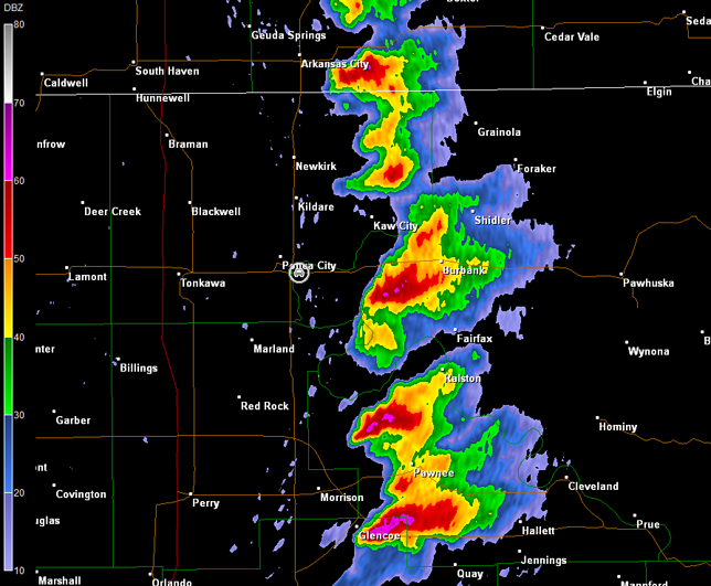
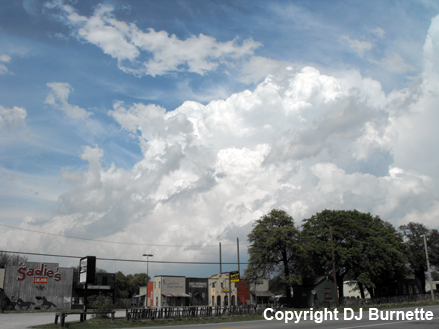
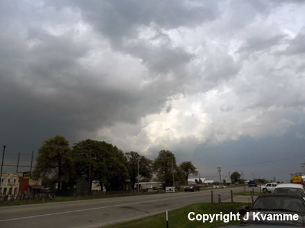
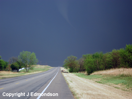
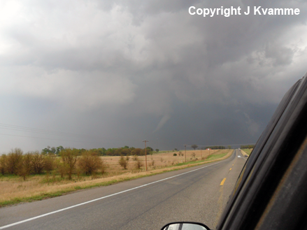
A fine line of towering cumulus clouds was noted on visible satellite imagery, as we had a quick lunch at the service area on U.S. 412 west of Tulsa. At 2:30 p.m. CDT, PDS (particularly dangerous situation) tornado watch number 135 was issued for much of eastern OK and northcentral/northeastern TX. Once we refueled, we continued west on U.S. 412 toward U.S. 177. However, thunderstorms were rapidly developing near the U.S. 177 corridor, and we quickly found ourselves in rain and a bit of hail. We cleared the storm's core before the hail became too big, and moved north on U.S. 177 into Ponca City, OK. We stopped on U.S. 60 in the far southern portions of Ponca City, waited for Cory Phelps to join us from Wichita, and watched the explosion of cumulonimbus clouds off to our north and east (images below; view is from the southern edge of Ponca City, looking north and east). Radar imagery during this time is also included below (car symbol denotes our location).
Vance Air Force Base, OK Storm Relative Velocity 2047Z
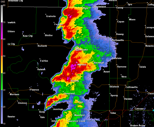
Vance Air Force Base, OK Base Reflectivity 2052Z
Vance Air Force Base, OK Storm Relative Velocity 2052Z
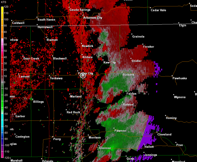
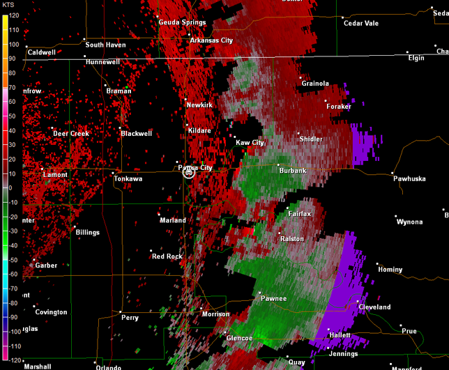
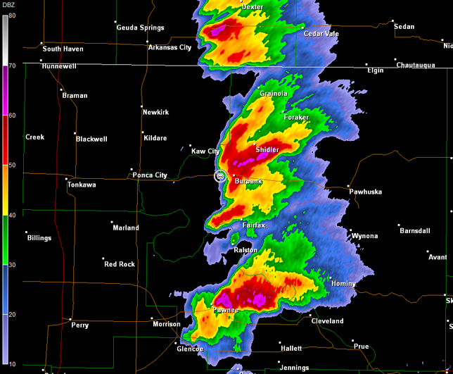
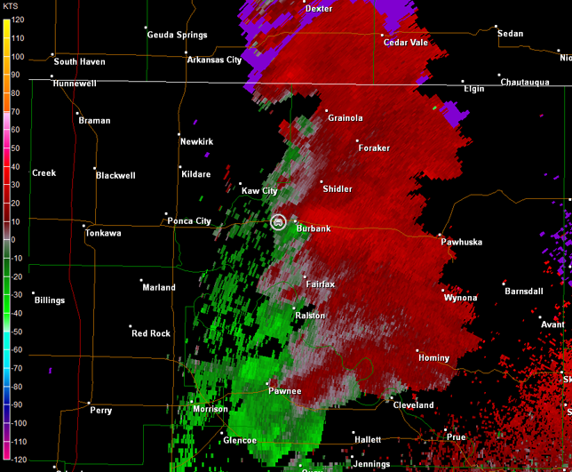
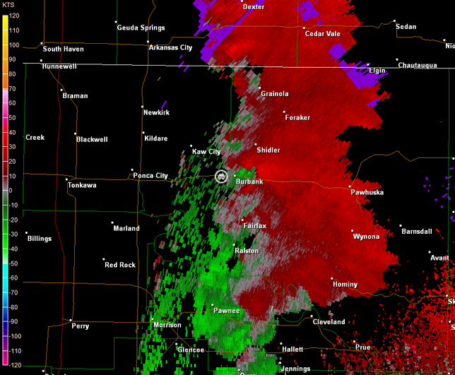
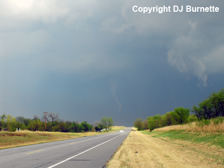
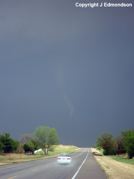
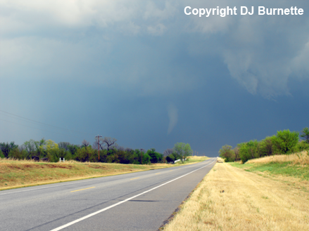
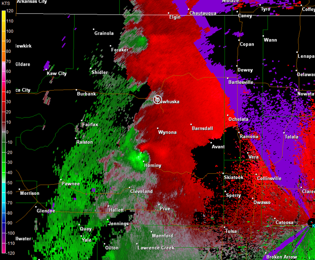
We were also monitoring the storm to our southeast (i.e., the one that blew up on top of us earlier). However, we were on the wrong side of all these storms (i.e., west of them). Thus, the objective was to intercept the backside of the storm to our southeast, as it crossed U.S. 60. A tornado warning was issued on the storm as we moved east on U.S. 60 toward the storm, and as we approached Burbank, OK, from the west, Cory Phelps noted a funnel cloud directly to our southeast about to cross U.S. 60. We immediately stopped to watch the sequence of events. This funnel cloud became a tornado as it crossed U.S. 60 (images below; view is west of Burbank, looking east), and calls were made to the Tulsa National Weather Service Forecast Office and WeatherData, Inc. to report the tornado. Radar imagery noted the best circulation over U.S. 60 at 2110Z (4:10 p.m. CDT), but widespread moderate to heavy rainfall was noted to the southeast of the circulation (images below; car symbol denotes our location; note the change in radar site from Vance AFB to Tulsa). Had we approached the storm from the southeast, it is very likely that we would have had greater difficulty observing this tornado.
Tulsa, OK Storm Relative Velocity 2110Z
Tulsa, OK Base Reflectivity 2114Z
Tulsa, OK Storm Relative Velocity 2114Z
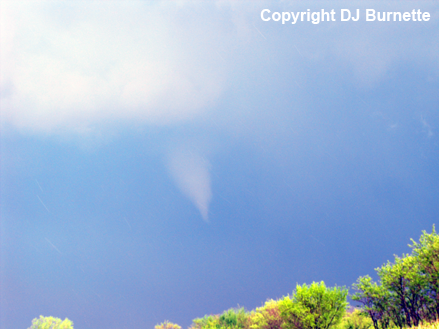
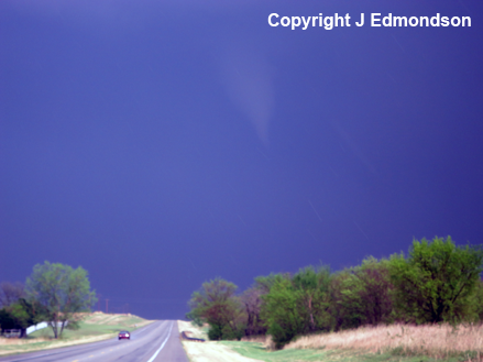
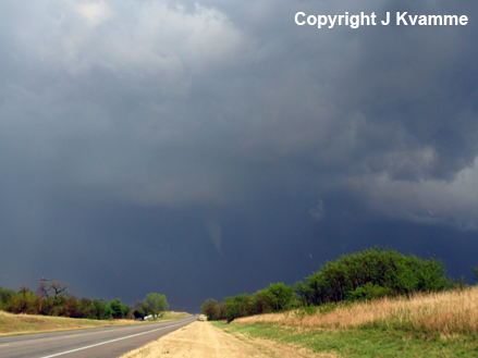
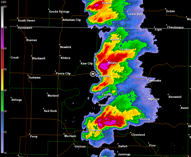
This tornado only damaged a few trees, and was officially rated was EF0. We chased the tornado eastward on U.S. 60, and watched it gradually lift. This storm looked less likely to produce tornadoes, as it continued to the northeast into a cooler environment. Meanwhile, two storms to our south were quite fierce with tornado warnings active for both. We stopped in Pawhuska, OK, to reassess the situation. Storm number one was just to our south, and radar imagery showed a likely tornado north of Hominy, OK (images below; car symbol denotes our location).
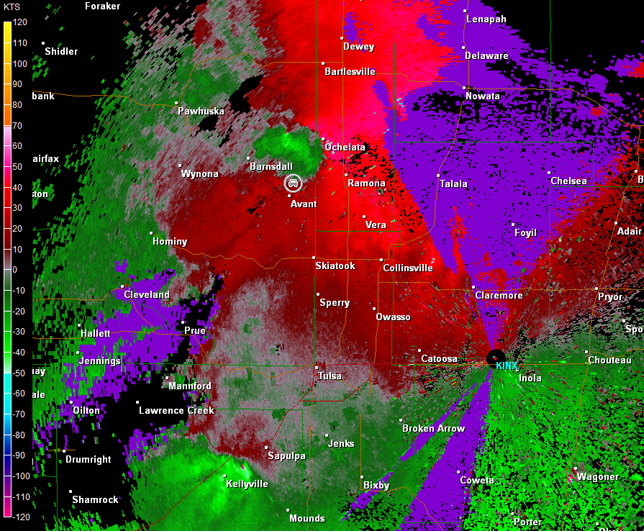
It would take a core punch through hail and heavy rain to reach this likely rain-wrapped tornado. This storm was also approaching an environment that would be less favorable for tornadoes. Given these issues, I began to focus on the beast moving northeastward up I-44 toward Tulsa. However, I planned to come around the backside of the Hominy storm just in case backbuilding occurred. As we approached Advant, OK, radar showed the main tornadic circulation was northwest of Ochelata, OK, and showing signs of occlusion (images below; car symbol denotes our location). There was another brief touchdown reported, as the storm moved north of Ochelata.
In retrospect, I should have had us move east of Pawhuska toward Bartlesville and then south on U.S. 75 toward Tulsa. We might have been able to see the tornado north of Ochelata had we done that. Regardless, that storm was continuing to move into a cooler environment, and it did lose strength shortly after 23Z (6 p.m. CDT). Meanwhile, storm number two continued to look quite fierce as it approached the southwestern sections of the Tulsa metro area (see radar images above). Thus, we continued south and east toward Tulsa.
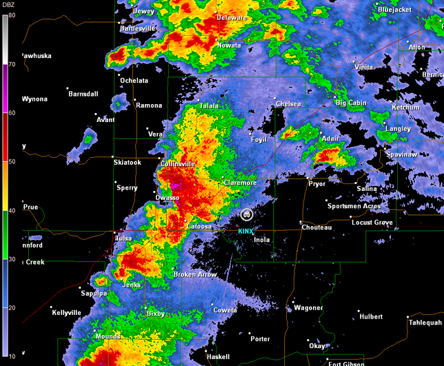
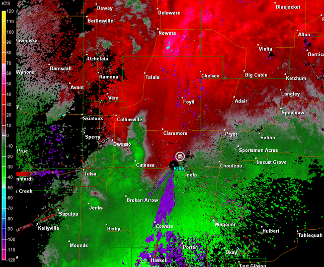
Unfortunately, the Tulsa metro area was in our way and would slow us down. I steered us around the northern and eastern metro by following OK-11 to OK-20 to OK-88. This still took some time, and the storm was gaining on us, as we moved through Claremore, OK, and then south-southeastward on OK-88 (radar images below; car symbol denotes our location).
This plan of attack would have worked well in seeing a tornado from that storm had the cell not diminished in intensity. Thankfully, it did diminish some or the folks in Tulsa would have had a major problem on their hands. We observed no lowerings with the storm, as we moved toward Inola, OK.
All the storms north of about I-40 were trending weaker, while the storms farther to the south near the Red River were quickly becoming the main show. This combined with the fact that terrain in OK becomes increasing poor for chasing east of U.S. 75, we decided to call it a day and head back to Fayetteville.