Storm Chase Log 27 March 2004
Chaser: Dorian J. Burnette
Preliminary Destination: Enid, OK
Note: Images have been decreased in size. Click on an image to view a larger version.
I left the University of Arkansas shortly after 10 a.m. CST bound for Enid, OK on U.S. 412. I arrived in Enid around 2 p.m. CST and made a brief stop to refuel. I also attempted to connect to the Internet during my stop. Unfortunately, the newest software dialer from Verizon refused to work and actually crashed Windows 2000 twice. While the technology is improving, Wireless connections are still not very good at times. Thankfully, Cory Phelps happened to call me while I was in Enid, and he gave me a good briefing on what was going on to my west and southwest.
After a stop in Enid, I moved westward on U.S. 412 out of town to decide which supercell to go after. I knew of two discrete supercells nearby. One was directly to my west in Woodward County and had a history of tornadoes (one large northeast of Vici, OK/southeast of Sharon, OK). The other was over 50 miles to my southwest, and would take some jogging around on various highways to get to. I called Guy Pearson at WeatherData, and he mentioned the better of the two at the moment was the Woodward County storm. Given that, the tornado history, and the fact that it was close made my final decision easy.
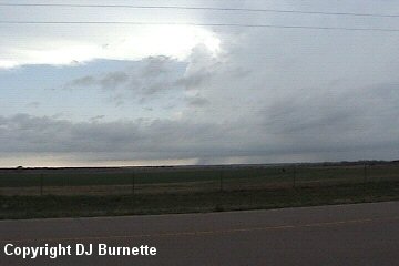
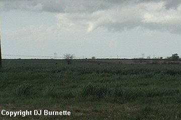
I moved westward on U.S. 412 toward the storm. The average sky condition from Fayetteville, AR all the way to Enid, OK was mostly cloudy. Although, there were several peaks of strong sunshine at times. I finally punched out from under the dumb low clouds, as I closed in on the storm (what a concept...I could now see the storm), and I immediately noticed a dying wall cloud. Once I arrived at the U.S. 412/Oklahoma Highway 8 interchage, I moved northward on Highway 8 in order to close in on the storm. I made a stop at this time to record some video of the supercell (images below; view is near Cleo Springs, OK looking west).
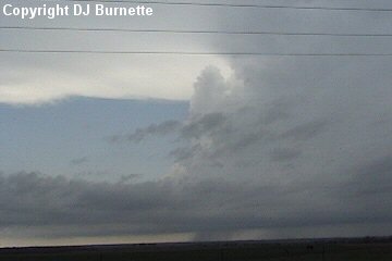
The storm (moving northeast) gradually closed in on me as I moved northward on Highway 8, and I could see some attempts at organization on the backside. I decided at that time to move closer to the rain-free base and observe the organization. Once I arrived at Oklahoma Highway 45, I took it west through the town of Carmen, OK and sat on Highway 45 west of Carmen and south of Dacoma, OK observing the organization.
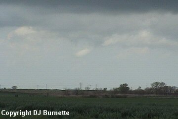
I took some video at this time (image above; view is west of Carmen looking west) showing the edge of the hailcore (greenish skies on the right side in the image) and the rain-free base. I called Guy Pearson at WeatherData and he mentioned that the storm had been showing good rotation. I mentioned to him that I had not observed anything other than some minor attempts at organization so far. Yet another storm where good rotation is noted on NEXRAD, but nothing is going on at the surface. Surface winds were veered off to the southwest for the moment, and Guy and I thought that might be the reason why.
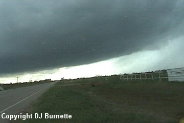
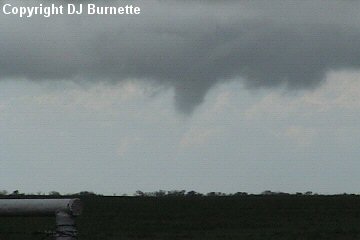
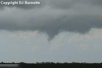
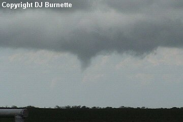
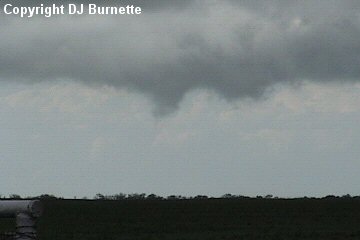
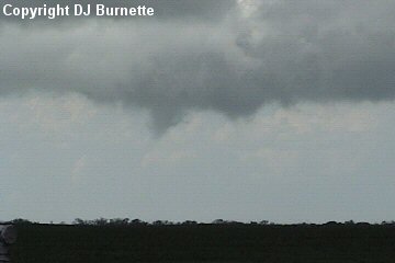
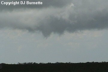
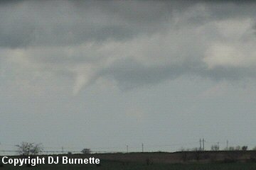
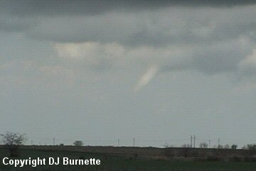
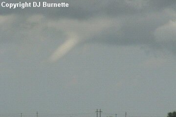
A short while later, a good rotating wall cloud and funnel cloud developed. It is possible that this was a weak tornado, as there was more than one time on the video where a "streak" of the condensation cloud attempted to extended all the way to the ground. It is difficult to say though, since I was not able to observe the state of the ground in vicinity of this funnel cloud. Thus, the ruling from my location is funnel cloud/possible tornado. The images are below (view is west of Carmen looking northwest toward Dacoma). The amount of time elapsed between the first image and the last image is a little over one minute.

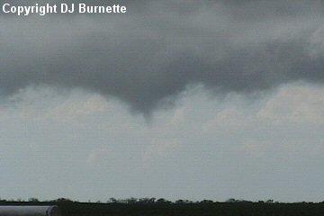
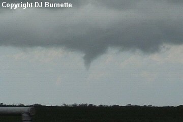
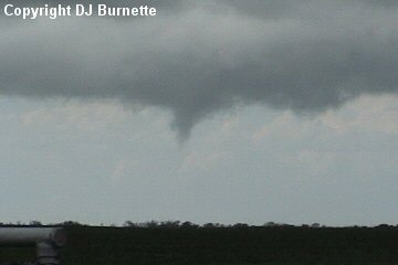
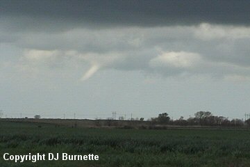
Once the funnel cloud dissipated, I started to move eastward on Highway 45 in order to prepare to follow the storm on to the north. As I began to move east, the storm developed another funnel cloud. Once again it is possible that weak circulation made it all the way to the ground. This funnel cloud was even farther away from me (which is the reason why some images are poor contrast), and I was not able to observe the state of the ground in vicinity of the funnel cloud. Thus, once again my thought is funnel cloud/possible tornado. The images are below (view is still west of Carmen looking northwest toward Dacoma). The amount of time elapsed between the first image and the last image is around one minute.
I continued to follow the storm moving east on Highway 45 to Highway 8 and then north into Cherokee, OK. By this time, the storm appeared to be dying, and a call to WeatherData confirms this. I then inquired about the storm to my south, which was now closing in on Enid. Guy Pearson mentioned that it was still healthy looking, and there was another one farther southwest yet that looked good too. Thus, I began to move back toward Enid, and I ran into the first of the two supercells once I got south of the city. My hope was to move south on Highway 81 quick enough to get around to the backside side of the storm before the hail intercepted me. That effort was futile, as I eventually ran into hail that began to increase in size. I had no intention of moving through a core of a storm that had a history of tornadoes, so I moved back into Enid and then east on U.S. 412 to punch through the rain a little farther to the northeast and get on the other side of the storm that way.
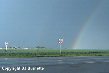
On my way, I observed a double rainbow. I took some quick video of that (image above; view is just east of Enid looking east) before continuing through the rain. This time I got completely through the rain with no hail encounters, and ended up east of Enid on U.S. 412 observing the storm to my west and southwest. I noted some attempts at organization, but nothing dramatic. I made one final call to WeatherData, and both Scott Breit and Guy Pearson mentioned that the storm I am on and the storm to the southwest of it were evolving into straight-line wind producers rather than tornado producers. With this being the case and the fact that it would soon be getting dark (it was now just before 7 p.m. CST), I decided to call the chase good and head back home.
Thanks to Scott Bryant, Andrew Gagnon, Wes Etheredge, Scott Breit, Guy Pearson, Cory Phelps, and Dean Jones for awesome comments and nowcasting support!