Storm Chase Log 9 July 2003
Chasers: Dorian J. Burnette, Jeff Donoho, and Tom Donoho
Preliminary Destination: southeast of Mount Hope, KS
Note: Images have been decreased in size. Click on an image to view a larger version.
This was a reaction chase. Severe thunderstorms were anticipated this day, but the tornado threat appeared to be minimal. I was spending time with my best friends in northwest Wichita, when I started to receive severe thunderstorm warnings on my mobile phone/pager across areas to the north of the Wichita. A look at the local radar showed one of the storms all by itself in Reno County. A feeling immediate arose in my stomach saying maybe that storm deserves a look. A short while later, a tornado warning was issued on the storm. Given the storm was close by, Tom, Jeff, and I decided to head northwest on K-96 to see if we could see anything. I did not have my normal chasing equipment with me (doh!), but Jeff grabbed a digital camera as we rushed out the door.
We moved northwest on K-96 toward Hutchinson, and heared off and on reports of wall clouds and funnel clouds. We stopped southeast of Mount Hope, KS, and watched the backend of the storm closely. We noted a wall cloud for a brief time. In addition, we noted range burning taking place (also observed in other areas during this storm chase) and smoke from this burning area was rising to the rain-free base of the storm in question and could easily be mistaken for a tornado. Again this is why extreme care must be excerised in reporting observations. There are many "tornado look-a-likes"...even experienced storm chasers (including myself) have been fooled by these.
The storm was turning hard to the right and backbuilding to the southwest. Thus, we were going to need to move in order to keep an eye on backend of the storm. We moved east on K-96 to 151st St. W. and then traveled south to Colwich. Unfortuantely, we were on the northeast side of the storm by this time, which meant the core of the storm was between us and the backend, where we continued to receive off and on reports of wall clouds and weak tornadoes.
Once we moved south of Colwich on 167th St. W. we began to come into view of the backend of the storm. We observed several lowerings, but unfortunately we 1) were too far away to ascertain how low the lowerings were and 2) had our view frequently obscured by trees. Cory Phelps called me a couple of times and mentioned he continued to hear reports of tornadoes to the southwest of our location. This seemed to fit our limited observations well.
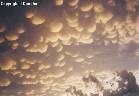
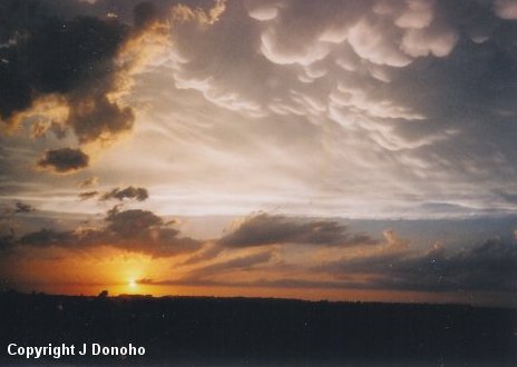
Several years ago, I was on a storm chase with Mark Bogner where a tornadic storm turned almost a full 180 degrees to the right of the mean flow (per radar analysis of the storm after our storm chase), and we were never able to catch up to the backend of the storm. This would be a similar case on this chase day, as we continued following the storm to the southwest, and eventually ended up taking K-2 into Harper, KS. The storm was continuing to move to the right of the mean flow and backbuilding to the southwest, and it was becoming increasingly apparent that we would not be able to catch the backend of the storm before sunset. By this time, the storm we were following was on the southern end of what was now a line of severe thunderstorms. Thus, we decided to head back toward home and punch through the line to see what it had in it. Some minor hail was noted, but high straight-line winds of 60 mph to perhaps 70 mph and blinding rain were the main show. Once we arrived on the backside of the line, we observed a tremendous display of mammatus clouds. Jeff Donoho snapped a couple of pictures of these on our way back (images below).