Storm Chase Log 25 June 2003
Chasers: Dorian J. Burnette, Andrew Gagnon, Brad Johnson, Archie Losey, and Cory Phelps
Preliminary Destination: Wellington, KS
Note: Images have been decreased in size. Click on an image to view a larger version.
A strong cold front for June was on the march across the Plains on this day. Despite its strength, the thunderstorms that developed along it only became nasty for a short while before becoming nothing more than a line of general showers and thunderstorms. Despite severe thunderstorms in vicinity of Wichita when we left (1:30 p.m. CDT), we decided to move south toward Wellington, which was at the north end of an area that had experienced quite a bit of sunshine through the morning into early afternoon.
On our way to the south out of Wichita, we ran into one storm after another that was developing along the cold front. The storms were gradually building farther back to the southwest along the cold front. Our objective was to stay on the southwest end of the line or attempt to catch any storms that developed ahead of the line. We made a brief stop at the Wellington, KS exit on the Kansas Turnpike and called WeatherData to make certain we were not missing anything going on to the north of us. Jeff House mentioned that we were definitely not missing anything. With that being the case, we continued to move farther south into OK.
Upon closing in on the Blackwell, OK area, we noted a thunderstorm attempting to develop well out ahead of the line to our east. We made a brief stop at Blackwell, OK in order to look at data on the Internet and call WeatherData for a second opinion. Without a doubt any storms on the tail end of the line or storms that could develop ahead of the line would be where we would want to be. Given that the line behind us was moving to the southeast, it would be easy to intercept the line if the storm attempting to develop to our east died. Thus, it would be in our best interest to go after the storm to our east, and we all elected to do just that. We moved east out of Blackwell, OK on Highway 11, and by the time we were northeast of Ponca City, we noted the storm to our east was not looking very healthy.
Thus, it was decided that we would head back to the line of storms, and setup on the southern-most storm. We moved westward on Highway 11, and then northward on U.S. 77 through Newkirk, OK. The closer we got to the KS/OK line, the more interesting the line became. We noted a couple of rain-free bases from our viewpoint...one off to our northwest and one directly to our north (toward Arkansas City, KS). The rain-free base to the north appeared to have a lowering that was becoming lower with time. However, the problem was we were a considerable distance away from it and unable to deduce for certain what was going on as a result. I immediately made a phone call to KSN, and Dave Freeman mentioned that lowering in vicinity of Arkansas City was in the wrong area of the storm to be anything tornadic. Unfortunately, the contrast on the video was too poor to reveal much, but what we observed may have been a microburst since reports of high straight-line winds were coming in around Arkansas City, KS around the same time.
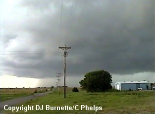
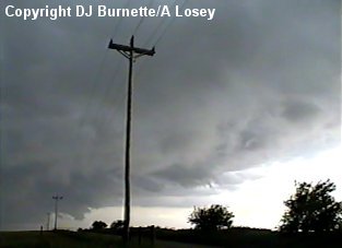
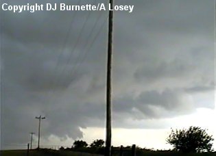
We edged a little closer to the KS/OK line, and had to stop as more organization took place in the backend of the storm to our northwest. Dave Freeman called me at this time to mention that there was some rotation now noted in the part of the storm we were looking at. The rotation was not great, but it was there. We observed a couple of minor wall clouds, but they were not persistent (images below...view is south of the KS/OK line on U.S. 77 looking northwest).
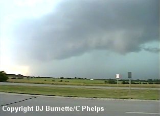
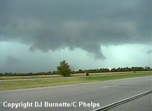
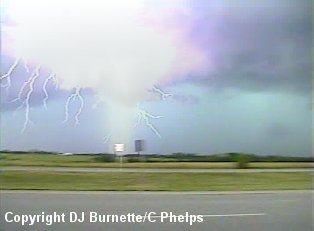
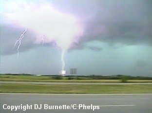
In addition, there were plenty of indications of hail (greenish tint to the skies in the images above and below) as well as plenty of cloud-to-ground lightning (images below...view is south of the KS/OK line on U.S. 77 looking northwest).
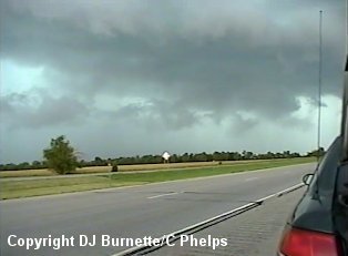
No strong rotation was ever noted, and the backend of the storm quickly became more of a shelf cloud than anything else (image above...view is south of the KS/OK line on U.S. 77 looking northwest). The storm was continuing to edge closer and closer to us, and we needed to move or be faced with blinding rain and hail. Thus, we moved southward on U.S. 77 to Highway 11, and then moved westward on Highway 11. We continued to keep an eye on the storm now to our north, but another one to our southwest was also catching our eye. We pulled over briefly on Highway 11 to see if the storm to our north was going to do anything else or not. Our observations indicated that it was weakening, and this weakening trend was confirmed by KSN. Thus, we decided to get on the storm to our southwest.
We moved west on Highway 11 into Blackwell, OK and then took U.S. 177 southward. This path allowed us to go around the core of the storm and approach the backside. Tornado sirens were sounding in Blackwell, OK, but no tornado warning was in effect (nor was one ever issued per WeatherData, Inc.). High straight-line winds, however, had been reported, and this probably prompted someone to panic and turn on the sirens. Some minor rotation was observed, as we arrived on the south side of Blackwell, OK. However, nothing tornadic was ever noted.
We continued to follow the back edge of the line of thunderstorms southward on U.S. 177, and our primary observations were that of a rather nasty looking shelf cloud. It gave those with me another good lesson in outflow boundaries, but the shelf cloud was definitely all bark and no bite (images below).
We made one last telephone call to WeatherData and Guy Pearson mentioned the storms were not very impressive any longer. This was in line with our observations. Thus, we moved through Perry, OK toward I-35, and took it back north toward home. On our way, we punched through the line of thunderstorms. Nothing severe whatsoever was noted...the line of storms had become very generic with just heavy rainfall noted.