Storm Chase Log 8 May 2003
Chasers: Dorian J. Burnette, Sarah Glenn, Greg Hutchinson, Cory Phelps, and Tim Stanley
Preliminary Destination: Emporia, KS
Note: Images have been decreased in size. Click on an image to view a larger version.
This chase day was a prime example of how you can make the perfect forecast, but it still all comes down to luck. The tornadoes were all rain-wrapped this day and low stratus clouds combined with lots of haze made storm structure very hard to see. I had my chase team sitting at Emporia State University until the storms began to explode. This also allowed me to see if any of my students had questions for their final exam coming up the following week. Some of my students came in and informed me that they observed The Weather Channel in town. Could this be a sign of things to come?
The thunderstorms began to explode along the dryline shortly before 5 p.m. CDT, and we decided to head out of Emporia and sit just west of the city. We continued to keep an eye on the radar and were listening to coverage on radio. The radio coverage this day was very good across all of eastern KS, and I commend them on their awesome performance. Eventually, the storms off to our southwest began to edge too close and we were forced eastward back through Emporia and ended up sitting just east of the city to be as far out of the rain as possible.
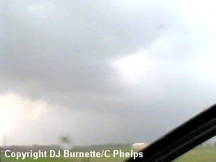
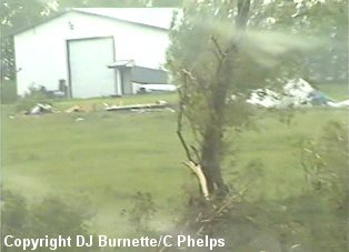
The storm structure from our position was impossible to observe. We did note lightning around the area and some greenish tint to the clouds here and there. We continued to observe things on the radar as well, and noted the storm to our west (now moving into the southwestern sections of Emporia) did have some rotation in the mid-levels. We also noted another storm to our south that was showing good rotation. We decided to make a call to WeatherData to get their take on the situation. Jeff House mentioned the storm to our south was indeed better looking, but since everything that had gone up had been spinning, it might be best to stay put. We continued to sit just east of Emporia watching the latest radar data. Once the storm moved just to the northeast of Emporia, it began to show strong rotation on NEXRAD storm-relative velocity data. Thus, we immediately moved back toward Emporia, and noticed a wall cloud as we approached the intersection of U.S. 50 and I-35 on the northeast side of Emporia. We had to drive through rain in order to get to wall cloud, and experienced off and on rain and alot of haze while we sat at the intersection observing the back end of the storm. The wall cloud dissipated rather quickly (before we could get any pictures), as the storm moved on to the northeast of Emporia. The images below were taken during this time. The view is looking north from the far northeastern corner of Emporia.
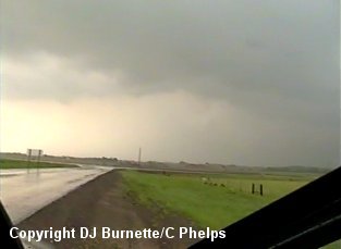
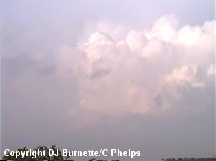
Despite the storm being on the edge of their viewing area, I called in a report to the KSN WeatherLab. We then took one last look at the radar data on the Internet before moving eastward in an attempt to keep up with the back end of the storm. Unfortunately, the storm was moving along to the northeast at a decent clip and we were slowed down once by very heavy rainfall. We eventually made it Lebo, KS and then moved north toward Melvern Lake. It was at this time that we heard of a report of a large tornado on the ground between Melvern Lake and Osage City (to our northeast by about 5 to 7 miles). Our plan was to move north, then east, then north, etc. in an attempt to catch up with the tornado. This plan would have worked had we not had to cut across the damage path. The image below showing the tornadic storm off in the distance was taken during this time. The view is looking north toward Osage City.
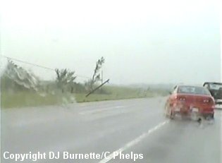
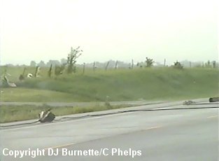
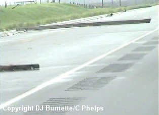
We took Highway 170 into Osage City and then moved east on Highway 31 toward Lyndon. Meanwhile, reports of the large tornado continued to come in...one mile west of Lyndon, then one mile north of Lyndon. To the west of the U.S. 75 junction, we noticed power poles leaning over near the road. We were able to get by that damage, but it was obvious the tornado went through that area. At the U.S. 75 junction, we turned toward the north, but unfortunately, we had to come to a sudden stop as emergency vehicles and police had shutdown the southbound lane of the highway due to damage on the west side of the highway. We took video of that damage (images below).
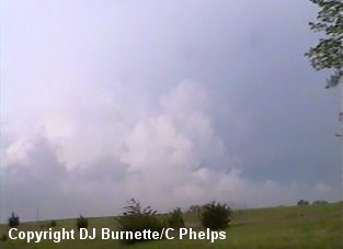
We remained stopped for some 10 minutes, before we could continue northward on U.S. 75 past the damage. While we were stopped, I made a call to WeatherData to see just how far in front of us the tornado was. Mike Doll mentioned it was not too far up to our northeast and that Mike Smith was on the storm and had observed the tornado. As an aside...I had a conversation with Mike Smith the day after this storm chase, and he mentioned he had to punch through rain in order to see the tornado. He was able to get good pictures of the tornado despite the fact that it was raining at the time he took them. We had done a good job at attempting to catch the storm, but the forced stop for 10 minutes nixed our chances at seeing that storm do anything. We continued to follow the storm moving north on U.S. 75 and then east on U.S. 56 (image of the tornadic storm below).
As the storm moved through the southern portions of Lawrence, KS, we noticed the structure did not appear to be overly sharp any longer, which is suggestive of weakening. A call to WeatherData confirms this weakening. Meanwhile the storm to our southeast in Linn county was a beast, so we decided to head in its general direction. Unfortunately, it was moving at a rather decent pace, we were behind it (like the earlier storm...we were in catch up mode), and darkness was approaching. As we moved south of Princeton, it become quite clear that we would not catch the storm unless we took a shortcut to the east to get to an area with good roads. This effort proved futile, however, as our dirt road turned into a utterly washout road. With that being the case and with darkness upon us, we decided to call off the pursuit and begin to head toward home.
There are a couple of good points I wish to make about this storm chase. First of all, this will be the last time that I ever chase the tail end of a storm by staying on its path. The reason being...if there is a tornado, you have a decent chance at running into the damage path and being slowed down or having your road totally blocked. Instead, I will just avoid following the path of the storm by moving far enough east to get out ahead of the storm, and then move to intercept. Another method is do just not let the storms get ahead of you. I know I have come to despise chasing storms that are ahead of me (i.e. "playing catch up"). I prefer to be ahead of them, so I can see everything going on and not have to concern myself with playing catch up or punching cores. The other point to make is that of looking at data on the Internet when in chase mode. Checking data on the Internet costs time, and I am convinced this time it cost us valuable seconds. I should not have checked the Internet one last time when I was on the back end of the tornadic storm northeast of Emporia. Instead, I should have trusted my instinct and followed it waiting until I was in a position where I would not have to move right away and then check the Internet. Bottom line...time is critical in the heat of the chase, so use your time wisely.