Storm Chase Log 12 June 2002
Chasers: Dorian J. Burnette, Lindsay Burge, Joseph Crane, Greg Hutchinson, Cory Phelps, and Todd Spacil
Preliminary Destination: Pratt, KS
Note: Images have been decreased in size. Click on an image to view a larger version.
This turned out to be a very frustrating chase day. The potential for tornadoes was there, but we were sidetracked early on and ended up way out of position. I must say that on this day it sure would have been nice to know where all the outflow boundaries were, as they were the major players in thunderstorm initation. This is a prime example of why hard data analysis must be done, and I do not mean model data analysis.
Despite this chase being incredibly frustrating, we did observe some interesting things. We arrived in Pratt around 3:30 p.m. CDT. We observed some growing towers around us, but they were having trouble. I made a call to KSN and WeatherData to let them know where we were and they mentioned we should start seeing things develop very shortly (a tornado watch had just been issued).
Shortly after 4 p.m. CDT, we noticed a good tower to our south. I made a phone call to WeatherData and Wes Etheredge mentioned that the storm was just across the Kansas/Oklahoma line southwest of Medicine Lodge and moving toward the northeast. Thus, we decided to move toward the south toward Medicine Lodge.
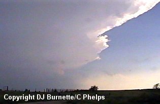
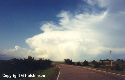
Just north of Medicine Lodge, we captured an image (above) of the growing storm. Eventually we ended up southwest of Medicine Lodge on a dirt road looking south at the storm. We were on the wrong side (northern side) of the storm. However, we were able to observe the rain-free base from our location, but nothing much was noted with it. We meandered around on dirt roads attempting to close in on the rain-free base. Eventually the dirt roads turned into mud roads, and we had significant trouble attempting to close in on the storm.
Meanwhile, another storm was developing to our north (southwest of Medicine Lodge), and we decided to wait between the two storms in far southern Barber County for one of the storms to show something interesting. Eventually a tornado warning was issued on the storm to our north. We could see the rain-free base from our viewpoint, but nothing any more than that. I made a phone call to WeatherData to let them know what we were observing. Wes Etheredge mentioned that the storm to our south just was not doing anything. He also mentioned that he was uncertain what the National Weather Service was observing on the one to our north to prompt a tornado warning. We decided to wait for about 15 minutes watching both storms, and then called Wes back to see if there was any significant change. He mentioned that the storm to our north was looking a little better organized now, and that the storm to the south was still not looking very healthy. Thus, we decided to make an attempt to move out of mud road central and catch up with the storm to our north, which was moving northeastward through Medicine Lodge at the moment.
During all this time, tornadoes were being reported out of the storms in Harper County and points eastward from there. We knew we had no chance of catching those storms, so we did the best with what we had and attempted to catch the storm up near Medicine Lodge. It took us a considerable amount of time to get off the mud roads. This mud road situation made me seriously think about my philosophy regarding chasing on dirt roads. The big thing that hurt us was that we strayed too far away from a main road, which is easy to do when storm chasing.
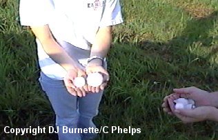
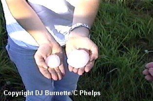
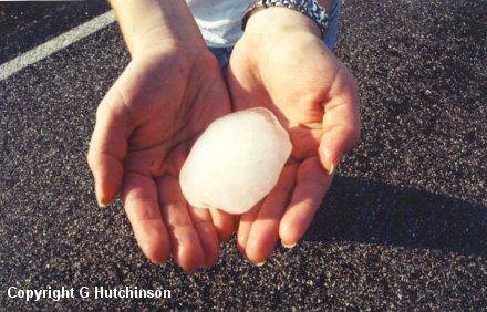
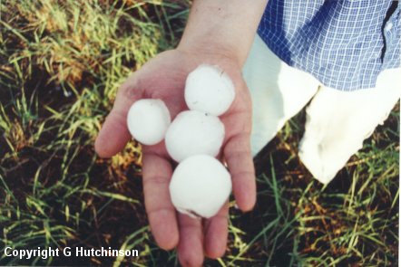
Eventually, we began to catch up to the storm and happened to pass across an area southwest of Medicine Lodge where the storm's hailcore at passed. Large hail was all over the ground, and had been there probably some 15 to 20 minutes in full sunshine. We stopped to take some pictures (images below). Lindsay, Todd, and Cory are holding the hailstones. Several of the hailstones were still the size of baseballs indicating they we likely softballs (perhaps a little larger) when they first came down. The hailstones created holes in the ground about an inch or so deep (a demonstration of how much force they have when they impact the ground or anything else for that matter).
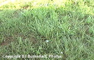
Greg Hutchinson got a good picture of the "hailstorm" (image below). I made a phone call to KSN and WeatherData to report the hail we found and that we were still tracking the storm with some lowerings off to our northeast. Eventually the storm ended up in Kingman County moving eastward near U.S. 54. We were still some distance to the south moving parallel to the storm on U.S. 160 in Barber and Harper Counties. We observed one wall cloud from a distance with the storm, but that was it. As we closed in on the back of the storm near Kingman, we noticed that it was not looking very healthy. A call to WeatherData confirms this (as a matter of fact the core of the storm moved across downtown Wichita with just hard rain noted and no hail).
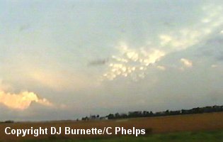
Thus we decided to end the storm chase by taking a picture of some well-defined mammatus clouds off to our south (image above), and then moved back toward Wichita. We did note some flooding of certain city streets (shocking!), as we moved through the city returning to Wichita State University.